El Sendero Grande - Torres del Paine
Even in patriotic South America it seems that the days of the national carrier are numbered. We shunned the Lan Chile flight south from Coihaique and instead plucked for the new budget airline "Sky Airline" at almost half the price. Bizarrely the motif on the tails is a palm tree under a blazing sun, not the sort of weather that we´ve been encountering in Patagonia, more likely courtesy of the failed airline from where the plane was sourced.
Punta Arenas, a colourful if chilly town at the extreme south of Chile, situated on the Straits of Magellan was where we had arranged to meet Jane. After a couple of nights in a shambolic hostel we headed north to Puerta Natales which would be our base for trekking Torres del Paine, the longest hike we intend undertaking on the trip. Eight days circling the three mighty granite massifs collectively known as the Torres del Paine.
Following a great view of the Torres from the bus the view was immediately obscured by foothills on day one as we started our anti-clockwise hike. The countryside was very similar to New Zealand farmland so a little disappointing but the promised views gleaned from the ubiquitous Torres postcards drove us on. Refugio Lago Dickson was our second night´s stop, the only refugio that we would pass that is not on the shorter W circuit. Although we were camping the rugby loving manager was only too happy to have a few antipodeans come in and chat for the night. The refugio was very casual, much more so than the four on the south side of the Torres and was the regular hang out for the local gauchos who could bring in their horses, whittle new pieces of wooden tack and drink mate (tea) by the litre.
From Lago Dickson the track ascended to camp Perros, from where we would make our way over Paso John Garner. Although only 1180 metres high it was spoken of in hushed tones on the trail and we were expecting to be challenged. By now the scenery was hotting up, the track to Perros offered great views back down the valley to Lago Dickson and later our first close view of a decent glacier on the trip. Glacier Perros, situated just before the camp was what we´d come to expect from the classic northern patagonian glacier. Sitting on a saddle between two 2000m high peaks ice creeps down to the terminal lake, occasionlly a chunk shears off that is large enough to form an iceberg. The camp itself was disappointing, the few decent piches required major irrigation before being habitable and as the running water was broken we didn´t even bother looking at the state of the toilets.
Day four was always going to be long and hard with a 700 metre climb to the pass followed by what the guide book described as a very steep 700 metre descent. We managed to set off at 8.00am, our best ever start as the weather had generally been better in the morning and headed for the snow covered pass. The ascent was technically very straight forward and (unusually) we didn´t have the howling patagonian wind to contend with so found the going pretty easy. The falling snow contributed a dose of serenity to the experience. Before we knew it we were on our way down and somewhat (though not ungratefully) underwhelmed by the difficulty of the task.
As we descended the pass proper the snow eased off and we were presented with the jaw droppingly spectacular view of glacier Grey, 17km in length from where it leaves the southern ice cap and several kilometres across it was on a totally different scale from any glacier we had seen before and looked truly other-worldly. Much time was spent gazing in total appreciation of such a wonderful natural monument and we were thankful for our luck in reaching the viewpoint in such fine weather. To give some sense of the scale of the glacier we would spend, in total, about a whole day hiking beside it. The descent to campamento paso was steep but with the aid of fixed ropes and the sturdy local undergrowth we managed to make the camp with no major mishaps. Unfortunately the camp was the least appealing we had come across so far and we decided to push on to the next campsite, Las Guardas a few kms and dodgy wooden ladders further down the glacial valley.
Campamento Las Guardas marked the point where the circuit trail met the W trail, the shorter version of the hike that seems to be a must do for every SA backpacker regardless of their equipment or physical ability (or interest in hiking?) and the empty trails to which we had been accustomed were a thing of the past. As we´d been warned "Once you hit the W, it´s mochilas, mochilas, mochilas !! " (backpacks - or in one case, a suitcase on wheels, no joke, check the last photo). Still we still had half a day hiking beside the vast expanse of Glacier Grey. Although none of them were as spectacular as the view from the pass the closer views allowed you to get a better sense of the scale of the crevasses and the icebergs that break off the face and float out in to Lago Grey. What´s more we passed our first refugio since Lago Dickson called Pehoe and availed ourselves of the free showers and the snack shop where we loaded up with more food supplies of chocolate, wine and canned goods. Comfort camping. We pushed on to Campamento Italiano to allow us a good crack at the French Valley the next day.
Day six and after a lazy start we set off up the French Valley to the sound of booming avalanches coming off the faces of the peaks surrounding glacier del Frances. Easily the largest avalanches we had ever seen, we were glad to be separated by a steep valley from where the action was taking place. The top of the valley opened up into an enormous bowl topped by 2000 metre high peaks, the curvature of the panorama giving the impression that you were looking through a wide angle lens (Jane often was). It was our second breath taking view of the hike and we were beginning to understand why it was so highly recommended and popular. Also, by camping at the foot of the valley we´d managed to pretty much have the view to ourselves. Clever us. As we´d hiked the valley without our packs it was no drama to move camp a little further round the valley to Los Cuernos for the night.
From Cuernos we followed the shores of Lago Nordenskjold to the valley of the Torres. The weather had deteriorated and it was a bit of a slog so cheered ourselves up with our first bought meal - 3 Barros Luco (a Chilean take on the cheeseburger) at refugio Chileno where we waited for the rain to stop and the Torres to come out from under the clouds. Eventually the rain stopped though the clouds pretty much stayed where they were and we set off up the valley for our last campsite Campamento Torres, another site where surface water retention was a problem. Solution - pitching tents on a 15 degree slope to avoid flooding, although you wake up crumpled at the foot of your tent. Before dusk we scooted up to the Torres lookout where about half the Torres could be seen, the top half disappearing into the clouds and leaving us guessing as to the true scale of the towers. Just as we arrived back at camp the clouds lifted and we caught a glimpse of the tops of the towers before night fell. We felt it was a good omen for our dawn expdition for the classic view of the first rays of sun turning the towers a vibrant orange.
Alas, it was not to be, 30mins before dusk the next morning the rain started up again and the clouds came in. Big styles. As the clouds settled around us we decided to break camp and head back down off the trail without really having had the close up view of the Torres that is the third "must see" of the hike. We´d have to do with our half views and make the rest up from postcard shots.
The walk out was a fairly uninspiring three hour slog in the rain. Brightened somehwhat by the views of the start of the trail where we´d been eight days earlier (oh yeah, and the dude with the suitcase) and the realisation of our achievement in completing the circuit in the full brunt of Patagonias weather arsenal, when other groups that had set out had pulled out early or cut out the side trips.
Then it was back to Puerto Natales for two days of high living and drying out, to prepare for our next adventure. Puerto Natales was by then a ghost town. 6 days left of the official season and the cold had settled in big style. Mind you I guess we were at a latitude well south of Stewart Island (or for the Aussies a bloody loooooooong way south of Tasmania). Oooh here´s some pickies ...
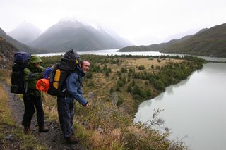
Cabin Fever on day 2. Brett tries to topple Nick off the track.
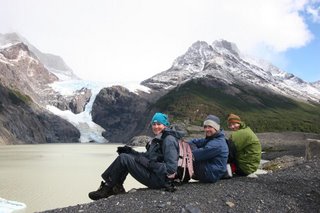
A break in the rain at Glaciar los Perros
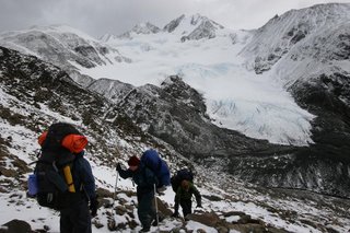
Up to John Garner Pass ...
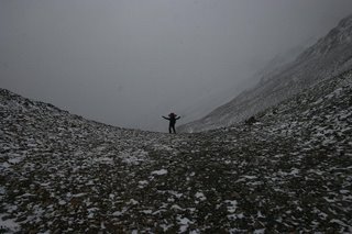
... and over the pass.
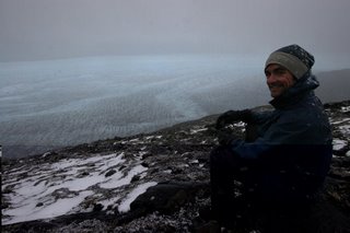
Looking down from the pass through falling snow over the vast blue expanse of Glacier Grey
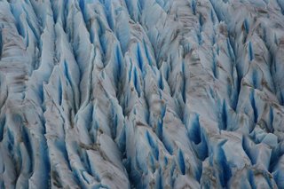
Blue ice of Grey (?)
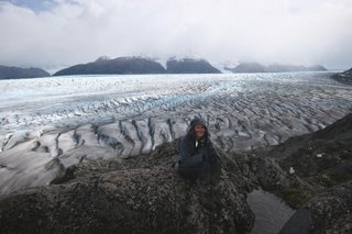
Jane at GG. Yes it was cold.
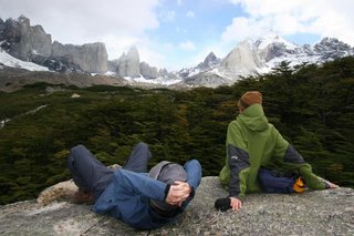
Checking out the circular vista in the Valle Frances
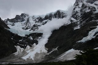
Avalanche in Valle Frances. About a 1km vertical drop ... well who knows it was a bloody long way. Sounded choice.
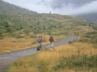
What are you thinking bro? By all accounts they turned back soon after this pic was taken
Punta Arenas, a colourful if chilly town at the extreme south of Chile, situated on the Straits of Magellan was where we had arranged to meet Jane. After a couple of nights in a shambolic hostel we headed north to Puerta Natales which would be our base for trekking Torres del Paine, the longest hike we intend undertaking on the trip. Eight days circling the three mighty granite massifs collectively known as the Torres del Paine.
Following a great view of the Torres from the bus the view was immediately obscured by foothills on day one as we started our anti-clockwise hike. The countryside was very similar to New Zealand farmland so a little disappointing but the promised views gleaned from the ubiquitous Torres postcards drove us on. Refugio Lago Dickson was our second night´s stop, the only refugio that we would pass that is not on the shorter W circuit. Although we were camping the rugby loving manager was only too happy to have a few antipodeans come in and chat for the night. The refugio was very casual, much more so than the four on the south side of the Torres and was the regular hang out for the local gauchos who could bring in their horses, whittle new pieces of wooden tack and drink mate (tea) by the litre.
From Lago Dickson the track ascended to camp Perros, from where we would make our way over Paso John Garner. Although only 1180 metres high it was spoken of in hushed tones on the trail and we were expecting to be challenged. By now the scenery was hotting up, the track to Perros offered great views back down the valley to Lago Dickson and later our first close view of a decent glacier on the trip. Glacier Perros, situated just before the camp was what we´d come to expect from the classic northern patagonian glacier. Sitting on a saddle between two 2000m high peaks ice creeps down to the terminal lake, occasionlly a chunk shears off that is large enough to form an iceberg. The camp itself was disappointing, the few decent piches required major irrigation before being habitable and as the running water was broken we didn´t even bother looking at the state of the toilets.
Day four was always going to be long and hard with a 700 metre climb to the pass followed by what the guide book described as a very steep 700 metre descent. We managed to set off at 8.00am, our best ever start as the weather had generally been better in the morning and headed for the snow covered pass. The ascent was technically very straight forward and (unusually) we didn´t have the howling patagonian wind to contend with so found the going pretty easy. The falling snow contributed a dose of serenity to the experience. Before we knew it we were on our way down and somewhat (though not ungratefully) underwhelmed by the difficulty of the task.
As we descended the pass proper the snow eased off and we were presented with the jaw droppingly spectacular view of glacier Grey, 17km in length from where it leaves the southern ice cap and several kilometres across it was on a totally different scale from any glacier we had seen before and looked truly other-worldly. Much time was spent gazing in total appreciation of such a wonderful natural monument and we were thankful for our luck in reaching the viewpoint in such fine weather. To give some sense of the scale of the glacier we would spend, in total, about a whole day hiking beside it. The descent to campamento paso was steep but with the aid of fixed ropes and the sturdy local undergrowth we managed to make the camp with no major mishaps. Unfortunately the camp was the least appealing we had come across so far and we decided to push on to the next campsite, Las Guardas a few kms and dodgy wooden ladders further down the glacial valley.
Campamento Las Guardas marked the point where the circuit trail met the W trail, the shorter version of the hike that seems to be a must do for every SA backpacker regardless of their equipment or physical ability (or interest in hiking?) and the empty trails to which we had been accustomed were a thing of the past. As we´d been warned "Once you hit the W, it´s mochilas, mochilas, mochilas !! " (backpacks - or in one case, a suitcase on wheels, no joke, check the last photo). Still we still had half a day hiking beside the vast expanse of Glacier Grey. Although none of them were as spectacular as the view from the pass the closer views allowed you to get a better sense of the scale of the crevasses and the icebergs that break off the face and float out in to Lago Grey. What´s more we passed our first refugio since Lago Dickson called Pehoe and availed ourselves of the free showers and the snack shop where we loaded up with more food supplies of chocolate, wine and canned goods. Comfort camping. We pushed on to Campamento Italiano to allow us a good crack at the French Valley the next day.
Day six and after a lazy start we set off up the French Valley to the sound of booming avalanches coming off the faces of the peaks surrounding glacier del Frances. Easily the largest avalanches we had ever seen, we were glad to be separated by a steep valley from where the action was taking place. The top of the valley opened up into an enormous bowl topped by 2000 metre high peaks, the curvature of the panorama giving the impression that you were looking through a wide angle lens (Jane often was). It was our second breath taking view of the hike and we were beginning to understand why it was so highly recommended and popular. Also, by camping at the foot of the valley we´d managed to pretty much have the view to ourselves. Clever us. As we´d hiked the valley without our packs it was no drama to move camp a little further round the valley to Los Cuernos for the night.
From Cuernos we followed the shores of Lago Nordenskjold to the valley of the Torres. The weather had deteriorated and it was a bit of a slog so cheered ourselves up with our first bought meal - 3 Barros Luco (a Chilean take on the cheeseburger) at refugio Chileno where we waited for the rain to stop and the Torres to come out from under the clouds. Eventually the rain stopped though the clouds pretty much stayed where they were and we set off up the valley for our last campsite Campamento Torres, another site where surface water retention was a problem. Solution - pitching tents on a 15 degree slope to avoid flooding, although you wake up crumpled at the foot of your tent. Before dusk we scooted up to the Torres lookout where about half the Torres could be seen, the top half disappearing into the clouds and leaving us guessing as to the true scale of the towers. Just as we arrived back at camp the clouds lifted and we caught a glimpse of the tops of the towers before night fell. We felt it was a good omen for our dawn expdition for the classic view of the first rays of sun turning the towers a vibrant orange.
Alas, it was not to be, 30mins before dusk the next morning the rain started up again and the clouds came in. Big styles. As the clouds settled around us we decided to break camp and head back down off the trail without really having had the close up view of the Torres that is the third "must see" of the hike. We´d have to do with our half views and make the rest up from postcard shots.
The walk out was a fairly uninspiring three hour slog in the rain. Brightened somehwhat by the views of the start of the trail where we´d been eight days earlier (oh yeah, and the dude with the suitcase) and the realisation of our achievement in completing the circuit in the full brunt of Patagonias weather arsenal, when other groups that had set out had pulled out early or cut out the side trips.
Then it was back to Puerto Natales for two days of high living and drying out, to prepare for our next adventure. Puerto Natales was by then a ghost town. 6 days left of the official season and the cold had settled in big style. Mind you I guess we were at a latitude well south of Stewart Island (or for the Aussies a bloody loooooooong way south of Tasmania). Oooh here´s some pickies ...

Cabin Fever on day 2. Brett tries to topple Nick off the track.

A break in the rain at Glaciar los Perros

Up to John Garner Pass ...

... and over the pass.

Looking down from the pass through falling snow over the vast blue expanse of Glacier Grey

Blue ice of Grey (?)

Jane at GG. Yes it was cold.

Checking out the circular vista in the Valle Frances

Avalanche in Valle Frances. About a 1km vertical drop ... well who knows it was a bloody long way. Sounded choice.

What are you thinking bro? By all accounts they turned back soon after this pic was taken

0 Comments:
Post a Comment
<< Home